Cover-up: Fukushima Nuclear Meltdown a Time Bomb Which Cannot be Defused

epa02660905 A handout picture provided by Air Photo Service on 30 March 2011 shows an aerial photo taken by a small unmanned drone of the damaged units of Tokyo Electric Power Co (TEPCO) Fukushima Daiichi nuclear power plant in the town of Okuma, Futaba district, Fukushima prefecture, Japan, 24 March 2011. TEPCO Chairman Tsunehisa Katsumata announced on 30 March it will be more than a few weeks to fix the Fukushima Daiichi nuclear power plant. EPA/AIR PHOTO SERVICE / HO EDITORIAL USE ONLY +++(c) dpa - Bildfunk+++

Four years after the Fukushima nuclear disaster which has caused incredible an ongoing destruction, in the meantime authorities have tried to cover up the serious consequences…

Image source: http://www.theasiasun.com/

Sourced through Scoop.it from: oilprice.com

>” […] Fukushima will likely go down in history as the biggest cover-up of the 21st Century. Governments and corporations are not leveling with citizens about the risks and dangers; similarly, truth itself, as an ethical standard, is at risk of going to shambles as the glue that holds together the trust and belief in society’s institutions. Ultimately, this is an example of how societies fail.

Tens of thousands of Fukushima residents remain in temporary housing more than four years after the horrific disaster of March 2011. Some areas on the outskirts of Fukushima have officially reopened to former residents, but many of those former residents are reluctant to return home because of widespread distrust of government claims that it is okay and safe. […]

According to Japan Times as of March 11, 2015: “There have been quite a few accidents and problems at the Fukushima plant in the past year, and we need to face the reality that they are causing anxiety and anger among people in Fukushima, as explained by Shunichi Tanaka at the Nuclear Regulation Authority. Furthermore, Mr. Tanaka said, there are numerous risks that could cause various accidents and problems.”

Even more ominously, Seiichi Mizuno, a former member of Japan’s House of Councillors (Upper House of Parliament, 1995-2001) in March 2015 said: “The biggest problem is the melt-through of reactor cores… We have groundwater contamination… The idea that the contaminated water is somehow blocked in the harbor is especially absurd. It is leaking directly into the ocean. There’s evidence of more than 40 known hotspot areas where extremely contaminated water is flowing directly into the ocean… We face huge problems with no prospect of solution.”

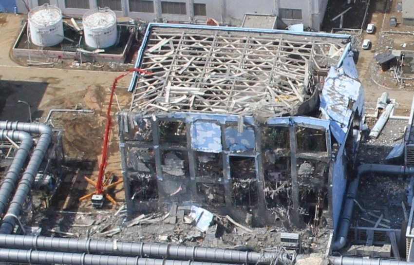
At Fukushima, each reactor required one million gallons of water per minute for cooling, but when the tsunami hit, the backup diesel generators were drowned. Units 1, 2, and 3 had meltdowns within days. There were four hydrogen explosions. Thereafter, the melting cores burrowed into the container vessels, maybe into the earth. […]

Following the meltdown, the Japanese government did not inform people of the ambient levels of radiation that blew back onto the island. Unfortunately and mistakenly, people fled away from the reactors to the highest radiation levels on the island at the time.

As the disaster happened, enormous levels of radiation hit Tokyo. The highest radiation detected in the Tokyo Metro area was in Saitama with cesium radiation levels detected at 919,000 becquerel (Bq) per square meter, a level almost twice as high as Chernobyl’s “permanent dead zone evacuation limit of 500,000 Bq” (source: Radiation Defense Project). For that reason, Dr. Caldicott strongly advises against travel to Japan and recommends avoiding Japanese food.

Even so, post the Fukushima disaster, Secretary of State Hillary Clinton signed an agreement with Japan that the U.S. would continue importing Japanese foodstuff. Therefore, Dr. Caldicott suggests people not vote for Hillary Clinton. One reckless dangerous precedent is enough for her. […]

Mari Yamaguchi, Associated Press (AP), June 12, 2015: “Four years after an earthquake and tsunami destroyed Japan’s Fukushima nuclear power plant, the road ahead remains riddled with unknowns… Experts have yet to pinpoint the exact location of the melted fuel inside the three reactors and study it, and still need to develop robots capable of working safely in such highly radioactive conditions. And then there’s the question of what to do with the waste… serious doubts about whether the cleanup can be completed within 40 years.” […]

According to the Smithsonian, April 30, 2015: “Birds Are in a Tailspin Four Years After Fukushima: Bird species are in sharp decline, and it is getting worse over time… Where it’s much, much hotter, it’s dead silent. You’ll see one or two birds if you’re lucky.” Developmental abnormalities of birds include cataracts, tumors, and asymmetries. Birds are spotted with strange white patches on their feathers.

Maya Moore, a former NHK news anchor, authored a book about the disaster:The Rose Garden of Fukushima (Tankobon, 2014), about the roses of Mr. Katsuhide Okada. Today, the garden has perished: “It’s just poisoned wasteland. The last time Mr. Okada actually went back there, he found baby crows that could not fly, that were blind. Mutations have begun with animals, with birds.” […] “<

See on Scoop.itGreen & Sustainable News

Advertisement

Alberta Pipeline Spills 5 Million Liters in Major Leak Near Oil Sands

Nexen Energy apologized Friday for a major leak in an Alberta pipeline that was only installed last year and said a warning system failed to detect it.

Sourced through Scoop.it from: www.news1130.com

>” […] A contractor discovered the leak Wednesday about 35 kilometres southeast of Fort McMurray, Alta. Nexen shut down the pipeline soon after, but not before some five million litres of bitumen, produced water and sand spilled into muskeg.

Nexen, which was taken over by China’s CNOOC Ltd. in 2013, says the affected area is about 16,000 square metres, mostly along the pipeline’s route. […]

John Bennett, national program director of the Sierra Club Canada Foundation, said he was worried.

“We’re always concerned when petroleum products get spilled into the environment. There’s always damage, and it’s usually permanent of some nature,” said Bennett. “It’s full of toxic elements that should not be released into the environment.” “<

See on Scoop.itGreen & Sustainable News

Water Quantities Used for Hydraulic Fracturing Varies According to Drilling Methods

The amount of water required to hydraulically fracture oil and gas wells varies widely across the country, according to the first national-scale analysis and map of hydraulic fracturing water usage detailed in a new USGS study accepted for publication in Water Resources Research, a journal of the American Geophysical Union.

Sourced through Scoop.it from: www.usgs.gov

>” […]  from 2000 to 2014, median annual water volume estimates for hydraulic fracturing in horizontal wells had increased from about 177,000 gallons per oil and gas well to more than 4 million gallons per oil well and 5.1 million gallons per gas well. Meanwhile, median water use in vertical and directional wells remained below 671,000 gallons per well. For comparison, an Olympic-sized swimming pool holds about 660,000 gallons.

“One of the most important things we found was that the amount of water used per well varies quite a bit, even within a single oil and gas basin,” said USGS scientist Tanya Gallegos, the study’s lead author. “This is important for land and resource managers, because a better understanding of the volumes of water injected for hydraulic fracturing could be a key to understanding the potential for some environmental impacts.”

Horizontal wells are those that are first drilled vertically or directionally (at an angle from straight down) to reach the unconventional oil or gas reservoir and then laterally along the oil or gas-bearing rock layers. This is done to increase the contact area with the reservoir rock and stimulate greater oil or gas production than could be achieved through vertical wells alone.

However, horizontal wells also generally require more water than vertical or directional wells. In fact, in 52 out of the 57 watersheds with the highest average water use for hydraulic fracturing, over 90 percent of the wells were horizontally drilled.

Although there has been an increase in the number of horizontal wells drilled since 2008, about 42 percent of new hydraulically fractured oil and gas wells completed in 2014 were still either vertical or directional. The ubiquity of the lower-water-use vertical and directional wells explains, in part, why the amount of water used per well is so variable across the United States.

The watersheds where the most water was used to hydraulically fracture wells on average coincided with parts of the following shale formations:

Eagle Ford (within watersheds located mainly in Texas)Haynesville-Bossier (within watersheds located mainly in Texas & Louisiana)Barnett (within watersheds located mainly in Texas)Fayetteville (within watersheds located in Arkansas)Woodford  (within watersheds located mainly in Oklahoma)Tuscaloosa  (within watersheds located in Louisiana & Mississippi)Marcellus & Utica (within watersheds located in parts of Ohio, Pennsylvania, West Virginia and within watersheds extending into southern New York)

Shale gas reservoirs are often hydraulically fractured using slick water, a fluid type that requires a lot of water. In contrast, tight oil formations like the Bakken (in parts of Montana and North Dakota) often use gel-based hydraulic fracturing treatment fluids, which generally contain lower amounts of water. […]”<

See on Scoop.itGreen & Sustainable News

Airplane Contrails Boost Global Warming by Trapping Earth’s Heat Energy

The warming effects of aircraft vapor trails could be eased with fewer night flights, especially during winter, the report says.

Sourced through Scoop.it from: news.nationalgeographic.com

>” […]

Nicola Stuber, first author of the study, to be published in tomorrow’s edition of the journal Nature, suggests that contrails’ overall impact on climate change is similar in scope to that of aircrafts’ carbon dioxide (CO2) emissions over a hundred-year period.

Aircraft are believed to be responsible for 2 to 3 percent of human CO2 emissions. Like other high, thin clouds, contrails reflect sunlight back into space and cool the planet.

However, they also trap energy in Earth’s atmosphere and boost the warming effect, the study says. […]

Contrails are artificial clouds that form around the tiny aerosol particles in airplane exhaust.

They appear only in moist, very cold (less than 40ºF/4ºC) air—usually at altitudes of 5 miles (8 kilometers) or higher.

Some contrails can last for a day or longer, though they gradually disperse and begin to resemble natural clouds.

Contrails Mystery Scientists disagree about the extent of contrails’ climate impact.

“The jury is out on the impact of contrails,” said Patrick Minnis, an atmospheric scientist at NASA’s Langley Research Center in Langley, Virginia.

David Travis, a climatologist at the University of Wisconsin-Whitewater, notes that some recent studies suggest that contrails have little impact on global climate change but have a greater regional warming impact.

“I prefer to think of contrails as a regional-scale climate problem, as they are most common in certain regions of the world, such as western Europe, eastern and central U.S., and parts of eastern Asia,” he said.

“This is due to a combination of dense air traffic in these areas and favorable atmospheric conditions to support contrail persistence once they form.”

Because of their locations and short life spans, contrails are a difficult study subject.

“The greatest impediment to understanding the contrail impacts on weather and climate is the poor state of knowledge of humidity in the upper troposphere [3.8 to 9.3 miles/6 to 15 kilometers in altitude],” NASA’s Minnis said.

“Until we can measure it properly and extensively, and model it and its interaction with cirrus clouds and contrails, we will continue to have large uncertainties about the effect of contrails.”

Winter is Contrail Season

At the high altitudes favored by commercial airlines, the air is much more humid in winter, so contrails are twice as likely in that season, study co-author Stuber said.

“We also found that flights between December and February contribute half of the annual mean climate warming, even though they account for less than a quarter of annual air traffic,” she said of her U.K.-based research.

Study leader Piers Forster, of England’s University of Leeds, suggests that contrails’ current impact on the atmosphere is likely to increase as air traffic grows. […]”<

See on Scoop.itGreen & Sustainable News

Jet Contrails Worse for Climate Change Than Aircraft Carbon Emissions

By John Timmer, Ars Technica

Air travel has come under fire for its potential contributions to climate change. Most people probably assume that its impact comes through carbon emissions, given that aircraft burn significant amounts of fossil fuel to stay aloft. But the carbon released by air travel remains a relatively minor part of the…

Sourced through Scoop.it from: www.wired.com

>” […]Others include the emissions of particulates high in the atmosphere, the production of nitrogen oxides and the direct production of clouds through contrail water vapor.

Over time, these thin lines of water evolve into “contrail cirrus” clouds that lose their linear features and become indistinguishable from the real thing.

Although low-altitude clouds tend to cool the planet by reflecting sunlight, high-altitude clouds like cirrus have an insulating effect and actually enhance warming.

To figure out the impact of these cirrus clouds, the authors created a module for an existing climate model (theECHAM4) that simulated the evolution of aircraft-induced cirrus clouds (they could validate some of the model’s output against satellite images of contrails).

They found hot spots of these clouds over the United States and Europe, as well as the North Atlantic travel corridor.

Smaller affects were seen in East Asia and over the northern Pacific. Over central Europe, values peaked at about 10 percent, in part because the output of the North Atlantic corridor drifted in that direction.

On their own, aircraft-generated cirrus produces a global climate forcing of about 40 milliwatts per square meter. (In contrast, the solar cycle results in changes of about a full watt/M2.)

But these clouds suppressed the formation of natural cirrus clouds, which partially offset the impact of the aircraft-generated ones, reducing the figure to about 30 mW/M2. That still leaves it among the most significant contribution to the climate produced by aircraft.

Some reports have suggested we might focus on makingengines that emit less water vapor, but the water is a necessary byproduct of burning hydrocarbon.

We’ll almost certainly be accomplishing that as a result of rising fuel prices, and will limit carbon emissions at the same time.

The nice thing is that, in contrast to the long atmospheric lifespan of CO2, if we can cause any changes in cloud formation, they’ll have an impact within a matter of days. […]”<

See on Scoop.itGreen & Sustainable News

IMF Reports Global Energy Subsidies are Unmanageable, Inefficient and Reinforce Inequality

A new report from the International Monetary Fund (IMF) urged policymakers the world over to reform subsidies for products from coal to gasoline, arguing that this could translate into major gains both for economic growth and the environment.

Image Source:  http://bit.ly/1LO0yQb

Source: www.imf.org

>” […] In a speech at the Peterson Institute for International Economics in Washington D.C., marking the release of the paper, IMF First Deputy Managing Director David Lipton noted that “subsidy reform can lead to a more efficient allocation of resources, which will help spur higher economic growth over the longer term.” Removing energy subsidies can also strengthen incentives for “research and development in energy-saving and alternative technologies,” he said. He also noted that, while intended to benefit consumers, subsidies are often inefficient and “could be replaced with better means of protecting the most vulnerable parts of the population.”

“The paper shows that for some countries the fiscal weight of energy subsidies is growing so large that budget deficits are becoming unmanageable and threaten the stability of the economy,” Mr. Lipton said, adding that IMF research shows that 20 countries maintain pre-tax energy subsidies that exceed 5 percent of GDP. For other emerging and developing countries, he said, the share of the scarce government resources spent on subsidies remains “a stumbling block” to higher growth and fundamentally impairs their future. “Because of low prices, there is little investment in much-needed infrastructure. More is spent on subsidies than on public health and education, undermining the development of human capital.”

Energy subsidies also reinforce inequality because they mostly benefit upper-income groups, which are the biggest consumers of energy. “On average, the richest 20 percent of households in low- and middle-income countries capture 43 percent of fuel subsidies,” said Mr. Lipton.

At the same time, Mr. Lipton warned that an increase in prices which can result from subsidy reform can have a significant impact on the poor and that “mitigating measures to protect them as subsidy reform is implemented” must be an integral part of any successful and equitable reform program.

In addition, Mr. Lipton noted that “subsidies aggravate climate change and worsen local pollution and congestion.” The study finds that eliminating pre-tax subsidies would reduce global CO2 emissions by about 1-2 percent which would, by itself, represent “a significant first step in reducing emissions by delivering about 15-30 percent of the Copenhagen Accord’s goal.” As for advanced economies, he noted that subsidies most often take the form of taxes that are too low to capture the true costs to society of energy use (“tax subsidies”), including pollution and road congestion. “Eliminating energy tax subsidies would deliver even more significant emissions reductions said Mr. Lipton, reducing “CO2 emissions by 4.5 billion tons, a 13 percent reduction.” […]”<

See on Scoop.itGreen & Sustainable News

Duke’s maligned handling of toxic coal ash is claimed typical for industry

Over 200 contaminations and spills document water contamination and deformed fish near coal ash sites.

Source: www.utilitydive.com

>” Duke Energy faces criminal charges and a $100 million fine for a 2014 spill of 39,000 tons of coal ash into North Carolina’s Dan River but environmental activists say its mishandling of coal ash waste is not atypical of the coal industry.  […] EPA released a final ruling on handling coal ash last December but both utility industry and environmental groups were dissatisfied. It creates requirements and standards for the management of coal combustion residuals (CCRs or coal ash) under Subtitle D of the federal Resource Conservation and Recovery Act (RCRA). That subtitle governs solid waste. There is not yet adequate data, the EPA said, to justify managing coal ash under Subtitle C of RCRA, which pertains to hazardous waste.

“Coal ash is a toxic soup of heavy metals,” said NC WARN Energy Expert Nancy LaPlaca. “Pretending it is not hazardous waste is outrageous.”

Utilities are “pleased” that the EPA found it did not have adequate information to regulate coal as hazardous waste, explained Schiff, Hardin Partner/Utilities Counsel Josh More. But “EPA is pretty explicit this is not their final determination.” It failed, he added, because “it is a self-implementing program.”  […]”<


See on Scoop.itGreen & Sustainable News

Crude Oil Spills From Pipeline Into Yellowstone River, Montana

Residents have reportedly smelled and tasted oil in their drinking water downstream from the spill, and the city’s water plant has stopped drawing from the river.

Source: thinkprogress.org

>” […] On Saturday morning, a pipeline in Montana spilled up to 50,000 gallons of crude oil into the Yellowstone River, the pipeline’s operator confirmed Sunday night. […]

The 12-inch diameter steel pipe breached and spilled anywhere from 12,600 to 50,000 gallons of oil nine miles upriver from the town of Glendive, with an unknown amount of it spilling into the partially frozen river, according to a statement from Bridger Pipeline LLC. The company said the spill occurred at 10 a.m. and they “shut in” the flow of oil just before 11 a.m. — meaning that though the pipeline section could still empty itself of its contents, no new addition oil would flow into the spilled area.

“Oil has made it into the river,” Bridger spokesperson Bill Salvin confirmed to the AP on Monday. “We do not know how much at this point.” Observers spotted oil, some of which was trapped under the ice, up to 60 miles downstream from Glendive. Paul Peronard, the EPA’s on-scene coordinator, said crews were attempting to use booms to prevent the spill from spreading further but the ice on top of the river was forcing them to “hunt and peck” through it.  […]

“We think it was caught pretty quick, and it was shut down,” said Montana Governor Steve Bullock spokesperson Dave Parker, noting that the river was frozen over near the spill, which could help isolate the spill.

Parker told MTN News that “the Governor is committed to ensuring that the river is completely cleaned up and the folks responsible are held accountable.”

In 2011, an Exxon Mobil pipeline spilled 63,000 gallons of crude oil into the Yellowstone near Laurel, Montana. Days after the spill, goat rancher Alexis Bonogofsky was hospitalized for acute hydrocarbon exposure after noticing oil slicks along the riverbank abutting her ranch. She lived far enough downstream that any evacuation order missed her, she said. There was concern then that the cause of the spill was related to climate-change-influenced raging floodwaters that exposed the normally deeply-buried pipe to damaging debris.

Even two years later, the state was still fighting with Exxon over damages to the area from the spill and the clean-up process, leaving fish, birds, and wildlife dead or injured and interrupting environmental studies, recreation, and fishing.

Bridger’s pipeline runs from the Canadian border down through Montana across the Missouri and Yellowstone rivers and east into North Dakota, dubbed the Poplar System. It is on the opposite side of Wyoming from, and downstream of, Yellowstone National Park, but the river empties into the Missouri River.

The proposed — and controversial — northern leg of the Keystone XL pipeline would bethree times the diameter of the breached Bridger pipeline, and pump more than 34 million gallons of oil per day through the Dakotas down into Nebraska and into the southern leg in Oklahoma and Texas. Many landowners and local residents are concerned about what a potential spill would mean for critical watersheds and aquifers — not to mention what subsequent increased tar sands oil production means for Canadian watersheds.”<


See on Scoop.itGreen & Sustainable News

University Researchers Find Abandoned Wells Leak Substantial Quantities of GHG’s (Methane)

After testing a sample of abandoned oil and natural gas wells in northwestern Pennsylvania, the researchers found that many of the old wells leaked substantial quantities of methane.

Source: www.princeton.edu

>” […] To conduct the research, the team placed enclosures called flux chambers over the tops of the wells. They also placed flux chambers nearby to measure the background emissions from the terrain and make sure the methane was emitted from the wells and not the surrounding area.

Although all the wells registered some level of methane, about 15 percent emitted the gas at a markedly higher level — thousands of times greater than the lower-level wells. Denise Mauzerall, a Princeton professor and a member of the research team, said a critical task is to discover the characteristics of these super-emitting wells.

Mauzerall said the relatively low number of high-emitting wells could offer a workable solution: while trying to plug every abandoned well in the country might be too costly to be realistic, dealing with the smaller number of high emitters could be possible.

“The fact that most of the methane is coming out of a small number of wells should make it easier to address if we can identify the high-emitting wells,” said Mauzerall, who has a joint appointment as a professor of civil and environmental engineering and as a professor of public and international affairs at the Woodrow Wilson School.

The researchers have used their results to extrapolate total methane emissions from abandoned wells in Pennsylvania, although they stress that the results are preliminary because of the relatively small sample. But based on that data, they estimate that emissions from abandoned wells represents as much as 10 percent of methane from human activities in Pennsylvania — about the same amount as caused by current oil and gas production. Also, unlike working wells, which have productive lifetimes of 10 to 15 years, abandoned wells can continue to leak methane for decades.

“This may be a significant source,” Mauzerall said. “There is no single silver bullet but if it turns out that we can cap or capture the methane coming off these really big emitters, that would make a substantial difference.” […]”<

See on Scoop.itGreen & Sustainable News

BP battles for billions in latest Gulf Oil Spill pollution trial

See on Scoop.itGreen & Sustainable News

HOUSTON/LONDON (Reuters) – BP will battle to hold down fines that could hit $18 billion in a new phase of the Gulf of Mexico trial that will rule on how much oil it spilled in 2010 and judge its efforts…

Duane Tilden‘s insight:

>POLLUTION FINES

BP says 3.26 million barrels leaked from the well during the nearly three months it took to cap the blowout at the Deepwater Horizon rig; the U.S. government says it was 4.9 million. Both those totals include 810,000 barrels that were collected during clean-up and which Barbier has agreed to exclude.

This month, BP’s lawyers questioned the government’s figure. “United States experts employ unproven methods that require significant assumptions and extrapolations in lieu of … available data and other evidence,” they said in a filing.

They have also sought to convince Barbier that if the company is to be found guilty, it should amount to only “negligence” and not “gross negligence” – a crucial distinction since the latter carries much higher maximum penalties.

Under the Clean Water Act, negligence can be punished with a maximum fine of $1,100 for each barrel of oil spilled; a gross negligence verdict carries a potential $4,300 per barrel fine.

If the court judged the spill to have been 4.09 million barrels – the government estimate less oil recovered – the price of negligence could reach $4.5 billion. Gross negligence, in the costliest scenario, could run to $17.6 billion.<

See on www.reuters.com