Hurricanes Cause Massive Damage
In light of recent events, such as the current hurricane season of 2017 which has already struck large sections of Texas with Hurricane Harvey causing massive damage which has been estimated at $180 billion by Texas Governor Greg Abbott (1) there are questions about how we can prepare cities better for disaster. One method considered is in our building codes, which are constantly being upgraded and improved, by constructing buildings to be more resilient and handle harsher conditions.
There is a limit to what a building code can do and enforce. Areas and regions that have seen widespread destruction, will have to be rebuilt. However, to what standards? The existing building codes will have to be examined for their efficacy in storm-proofing buildings to withstand the effects of high winds and water penetration, some of which has already been performed.
Codes do not prevent external disasters such as from storms, tornadoes, tidal waves (tsunami), earthquakes, forest fire, lightning, landslides, nuclear melt-down and other extreme natural and man-made events. What building codes do is establish minimum standards of construction for various types of buildings and structures. Damage to buildings, vehicles, roads, power systems and other components of a city’s infrastructure are vulnerable to flooding which cannot be addressed in a building code. Other standards are needed to address this problem.
Storm-Proofing Cities
Other issues arise regarding flooding, and how water can be better managed in the future to mitigate water collection and drainage. These may require higher levels of involvement across a community and perhaps beyond municipal constraints, requiring state-wide developments. Breakwaters, sea walls, levees, spill ways and other forms of structures may be added to emergency pumping stations and micro-grid generator/storage facilities as examples of infrastructure improvements that could be utilized.
Bigger decisions may have to be considered as to the level of reconstruction of buildings in vulnerable areas. Sea warming as noted occurring has some scientists pondering if there is a connection between global warming and increased storm volatility as indicated by water temperature rises and tidal records (2). If bigger and more frequent storms are to come, then it must be considered in future building and infrastructure planning.
Regional Infrastructure and Resiliency
Exposed regions as well as larger, regional concerns in areas of maintaining power, roadways, and diverting and draining water are major in the resiliency of a community. When a social network breaks down, there is much lost, and recovery of a region can be adversely affected by loss of property and work.
Many of the lower classes will not have insurance and lose everything. Sick and elderly can be especially exposed, not having means to prepare or escape an oncoming disaster, and many will likely perish unless they can get access to aide or a shelter quickly.
Constructing better sea walls and storm surge barriers may be an effective means to diverting water in the event of a hurricane on densely populated coastal areas. Although considered costly to construct, they are a fraction of the cost of damage that may be caused by a high, forceful storm surge which can obliterate large unprotected populated areas. The Netherlands and England have made major advancements in coastal preparedness for storms.
Storm Surge Barriers
Overall Effectiveness for Reducing Flood Damage
There are only a few storm surge barriers in the United States, although major systems installed abroad demonstrate their efficacy. The Eastern Scheldt barrier in the Netherlands (completed in 1986) and the Thames barrier in the United Kingdom (completed in 1982) have prevented major flooding. Lavery and Donovan (2005) note that the Thames barrier, part of a flood risk reduction system of barriers, floodgates, floodwalls, and embankments, has reliably protected the City of London from North Sea storm surge since its completion.
Four storm surge barriers were constructed by the USACE in New England in the 1960s (Fox Point, Stamford, New Bedford, and Pawcatuck) and a fifth in 1986 in New London, Connecticut. The barriers were designed after a series of severe hurricanes struck New England in 1938, 1944, and 1954 (see Appendix B), which highlighted the vulnerability of the area. The 1938 hurricane damaged or destroyed 200,000 buildings and caused 600 fatalities (Morang, 2007; Pielke et al., 2008).
The 2,880-ft (878-m) Fox Point Barrier (Figure 1-8) stretches across
the Providence River, protecting downtown Providence, Rhode Island. The barrier successfully prevented a 2-ft (0.6-m) surge elevation (in excess of tide elevation) from Hurricane Gloria in 1985 and a 4-ft (1.2-m) surge from Hurricane Bob in 1991 (Morang, 2007) and was also used during Hurricane Sandy. The New Bedford, Massachusetts, Hurricane Barrier consists of a 4,500-ft-long (1372-m) earthen levee with a stone cap to an elevation of 20 ft (6 m), with a 150-ft-wide (46-m) gate for navigation. The barrier was reportedly effective during Hurricane Bob (1991), an unnamed coastal storm in 1997 (Morang, 2007), and Hurricane Sandy. During Hurricane Sandy, the peak total height of water (tide plus storm surge) was 6.8 feet (2.1 m), similar to the levels reached in 1991 and 1997. The Stamford, Connecticut, Hurricane Barrier has experienced six storms producing a surge of 9.0 ft (2.7 m) or higher between its completion (1969) and Hurricane Sandy. During Hurricane Sandy, the barrier experienced a storm surge of 11.1 ft (3.4 m), exceeding that of the 1938 hurricane (USACE, 2012). (3)
The biggest challenge is to build storm surge barriers large enough for future Hurricanes. There is a question that given the magnitude of current and future storms that these constructed barriers may be breached. Engineers design structures to meet certain standards, and with weather these were the unlikely 1 in 100 year storm events. However, this standard is not good enough as Hurricane Katrina in Louisiana exemplified, as being rated a 1 in 250 year storm event. With climate changes these events may become more frequent.
Much of the damage from Katrina came not from high winds or rain but from storm surge that caused breaches in levees and floodwalls, pouring water into 80 percent of New Orleans. To the south, Katrina flooded all of St. Bernard Parish and the east bank of Plaquemines Parish. Plaquemines Parish flooded again in 2012 with Hurricane Isaac.
Soon after Katrina, Congress directed the Corps of Engineers to build a system that could protect against a storm that has a 1 percent chance of happening each year, a “1-in-100-year” storm.
The standard is less a measure of safety and more a benchmark that allows the city to be covered by the National Flood Insurance Program. Louisiana’s master coastal plan calls for a much stronger 500-year system. The corps says Katrina was a 250-year storm for the New Orleans area.
Since 2005, the Army Corps has revamped the storm protection system’s 350 miles of levees and floodwalls, 73 pumping stations, three canal-closure structures, and four gated outlets. The corps built a much-heralded 26-foot-high, 1.8-mile surge barrier in Lake Borgne, about 12 miles east of the center of the city.
During Katrina, a 15- to 16-foot-high storm surge in Lake Borgne forced its way into the Intracoastal Waterway, putting pressure on the Industrial Canal levees that breached and caused catastrophic flooding in the city’s Lower 9th Ward.
“In New Orleans, we know that no matter how high we build this or how wide we build it, eventually there will be a storm that’s able to overtop it,” New Orleans District Army Corps spokesman Ricky Boyett says, admiring the immense surge barrier from a boat on Lake Borgne. “What we want is this to be a strong structure that will be able to withstand that with limited to no damage from the overtopping.” (4)
500 Year Floods
Hurricane Harvey brought an immense amount of extreme rain, which brought a record 64″ in one storm to the Houston metropolitan region. This is a staggering amount of water, over 5 feet in height, this amount of water could only overwhelm low-lying areas, and depressions in topography. Flash floods can happen during extreme storms, where a drainage system is designed for a 1:100 year flood event, and not for a 1:500 or 1:1000 year flood event. Road ways can easily become rivers as drainage systems back up and surface water has no place to collect.

Figure 1. 500 year flood events in the USA since 2015 (5)
New standards in development may need to accommodate more stringent standards. Existing municipal drainage systems are not designed to handle extreme rain and other means of drainage systems may have to be developed to divert water away from centers of population. Communities will be built to new standards, where storm water management is given a higher priority to avert flooding.
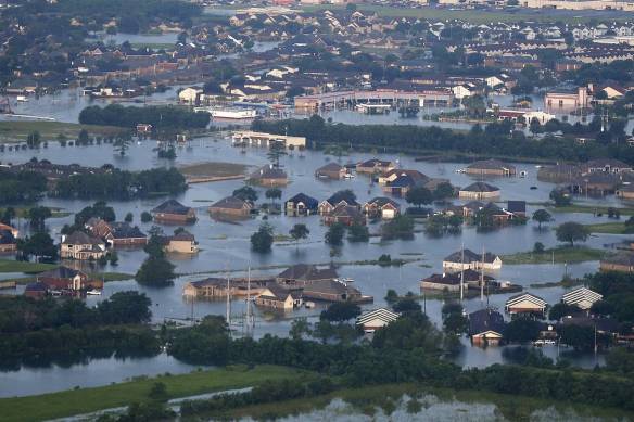
Figure 2. Floodwaters from Tropical Storm Harvey (6)
Given the future uncertainty of our climate and weather, we cannot continue to ignore the devastating effects that disasters have on cities and regions. We must ask some difficult questions regarding the intelligence of continuing to build and live in increasingly higher risk regions.
On a personal level every citizen must take some responsibility in their choices of where to live. As for governments they need to decide how best to allocate limited resources in rebuilding and upgrading storm protection systems. It is anticipated that some areas will be abandoned as risks become too high for effective protection from future storm events.
The Oil and Gas Industry
It seems there is an irony involved with the possibility that storms severity is linked to global warming, and that access to vulnerable regions often are in part economically driven by the oil and gas industry. Hurricane Harvey is the most recent storm which is affecting fuel prices across the USA. Refinery capacity has shrunk due to plant shut-downs. Shortages in local fuel supplies are occurring, as remaining gasoline stations run dry.
Goldman Sachs estimates that the hurricane has taken 3 million barrels a day — or about 17% — of refining capacity offline, and that’s likely to increase the overall level of crude-oil inventories over the next couple of months. (7)
Oil and gas are particularly vulnerable to exposure to the weather, and it is in their own best interests to provide local protection to the area so that they can continue extracting the resource. However, ancillary industries such as refining may better be served by relocation away from danger areas. Also, supply lines become choked by disaster, and can potentially have consequences beyond the region which was exposed to the disaster.
The Electric Vehicle in the Smart City
Such events can only put upward pressure on the price of fuel, while providing further incentive to move away from the internal combustion engine as means of motive power. Electric vehicles would provide a much better ability to recover quickly from storm events as they are not restricted by access to fuel. Micro-grids in cities provide sectors of available power for which electric emergency response vehicles can move.
By moving reliance away from carbon based fuels to renewable electric sources and energy storage, future development in cities may see the benefits inherent in the electric vehicle. Burning fuels create heat, water and carbon dioxide in the combustion process. They consume our breathable oxygen and pollute the atmosphere. Pipelines, tankers and rail cars can break and spill causing pollution. Exploration causes damage to the environment.
A city that is energy efficient and reliant on renewable sources of energy that benignly interact with the environment can approach self-sustainability and a high degree of resilience against disaster. This combined with designing to much higher standards which keep in mind the current volatility our climate is experiencing, and uses the lessons learned in other areas as indicators of best practices into the future.
References
- Hurricane Harvey Damages Could Cost up to $180 Billion
- Global warming is ‘causing more hurricanes’
- “3 Performance of Coastal Risk Reduction Strategies.” National Research Council. 2014. Reducing Coastal Risk on the East and Gulf Coasts. Washington, DC: The National Academies Press. doi: 10.17226/18811.
- Rising Sea Levels May Limit New Orleans Adaptation Efforts
- Houston is experiencing its third ‘500-year’ flood in 3 years. How is that possible?
- Hurricane Harvey Slams Texas With Devastating Force
- GOLDMAN: Harvey’s damage to America’s oil industry could last several months

