See on Scoop.it – Green Building Design – Architecture & Engineering
NASA researchers studying have found that the intensity of the “heat island” created by a city depends on the ecosystem it replaced and on the regional climate.
I have measured the heat island effect in the Greater Vancouver area, specifically Metrotown, Burnaby to be in the order of 6 deg C, during a late summer evening.
>”The placement and structure of cities — and what was there before — really does matter,” said Marc Imhoff, biologist and remote sensing specialist at NASA’s Goddard Space Flight Center in Greenbelt, Md. “The amount of the heat differential between the city and the surrounding environment depends on how much of the ground is covered by trees and vegetation. Understanding urban heating will be important for building new cities and retrofitting existing ones.”
Goddard researchers including Imhoff, Lahouari Bounoua, Ping Zhang, and Robert Wolfe presented their findings on Dec. 16 in San Francisco at the Fall Meeting of the American Geophysical Union.
Scientists first discovered the heat island effect in the 1800s when they observed cities growing warmer than surrounding rural areas, particularly in summer. Urban surfaces of asphalt, concrete, and other materials — also referred to as “impervious surfaces” — absorb more solar radiation by day. At night, much of that heat is given up to the urban air, creating a warm bubble over a city that can be as much as 1 to 3°C (2 to 5°F) higher than temperatures in surrounding rural areas.
The impervious surfaces of cities also lead to faster runoff from land, reducing the natural cooling effects of water on the landscape. More importantly, the lack of trees and other vegetation means less evapotranspiration — the process by which trees “exhale” water. Trees also provide shade, a secondary cooling effect in urban landscapes.
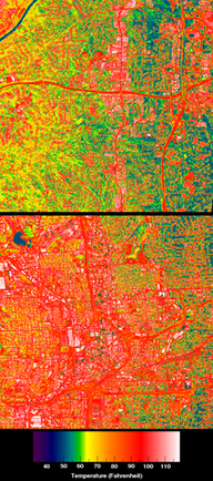
Using instruments from NASA’s Terra and Aqua satellites, as well as the joint U.S. Geological Survey-NASA satellite Landsat, researchers created land-use maps distinguishing urban surfaces from vegetation. The team then used computer models to assess the impact of urbanized land on energy, water, and carbon balances at Earth’s surface. <
See on www.nasa.gov
